
The shifting dynamics of global weather patterns have turned seasonal forecasting into an essential blueprint for modern life. Across the United Kingdom, the arrival of June marks a critical turning point where individuals, agricultural planners, and municipal operators look toward long-range modeling to navigate the coming months.
Following a record-breaking spring season that brought intense warmth to England and Wales, the latest atmospheric projections indicate a highly dynamic summer ahead. Understanding these long-range shifts is vital for anyone managing logistical supply chains, planning retail operations, or coordinating infrastructure readiness.
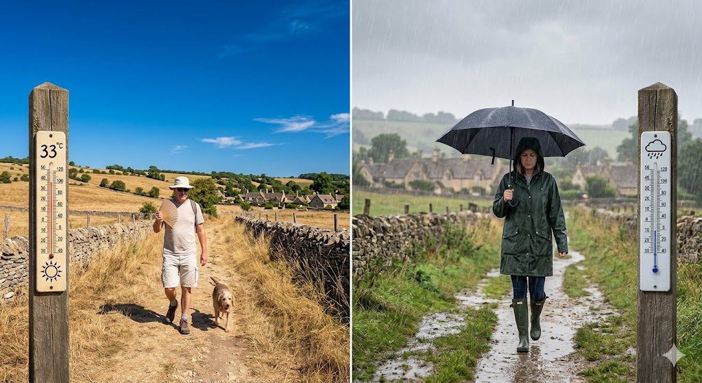
The Dynamic Baseline of Summer 2026
The structural framework of British summers has transformed over the past few decades, replacing historic predictability with stark meteorological volatility. According to the newly released BBC Weather Summer Outlook, the United Kingdom is entering a summer season defined by pronounced thermal swings and highly localized precipitation anomalies.
This year’s modeling arrives on the heels of a historic spring that concluded with a late-May bank holiday heatwave, pushing localized temperatures in London and the southeast up to an intense 34°C to 35°C. This extreme heat distribution provided an early preview of the larger macroeconomic and atmospheric forces shaping the continent’s climate trends.
To accurately prepare for the coming months, it is essential to examine the underlying climate drivers, monthly transitions, and regional variations outlined by the BBC Weather Summer Outlook. This comprehensive analysis unpacks the core science and practical realities behind the projected heatwaves and rainfall trends across the country.
1. Macro Climate Drivers: The El Niño Influence and “Climate Whiplash.”
The overarching weather trends across Northern Europe cannot be evaluated in isolation from macro-climatic global events. The primary force driving the volatility highlighted in the BBC Weather Summer Outlook is the rapid redevelopment of El Niño conditions in the tropical Pacific Ocean.
The US National Oceanic and Atmospheric Administration (NOAA) confirms an 82% probability of a strong El Niño emerging between May and July 2026, with that probability climbing to 96% heading into the winter. When these massive oceanic warming events interact with a planet already experiencing elevated baseline temperatures, the result is an amplification of extreme seasonal weather patterns.
Meteorologists are increasingly using the term “climate whiplash” to describe these sharp, rapid swings from one extreme to another. Following an exceptionally wet winter that brought weeks of continuous downpours to parts of Devon and Cornwall, the BBC Weather Summer Outlook indicates that the atmospheric pendulum is poised to swing toward notable heat risks, punctuated by sudden convective downpours.
- Sustained Atmospheric Warming: The Met Office projects that 2026 is on track to be the fourth consecutive year where global average temperatures exceed 1.4°C above pre-industrial levels.
- Jet Stream Deceleration: This intense global heat is causing the North Atlantic jet stream to buckle and stall, leaving high-pressure ridges or low-pressure troughs hovering over the UK for extended blocks of time.
- Elevated Absolute Humidity: Saturated air masses moving over warmer-than-average coastal waters carry superior moisture loads, providing the raw fuel for high-intensity summer thunderstorms.
2. June Outlook: An Unsettled Start Giving Way to High Pressure
According to the sub-seasonal modeling detailed in the BBC Weather Summer Outlook, the month of June is shaping up to be a true game of two halves. The month has opened with a distinctly fresher, cooler feel compared to the sweltering final weeks of May, as Atlantic frontal systems reassert their temporary control over the British Isles.
During the first half of June, a series of low-pressure troughs is expected to sweep across the country from the northwest. These systems will bring cooler, near-normal temperatures alongside regular bands of rain and blustery conditions, offering a welcome break for gardeners and water authorities.
However, this unsettled period is not a permanent indicator for the rest of the season. The BBC Weather Summer Outlook highlights a strong meteorological signal for an atmospheric shift during the second half of June, as a robust high-pressure ridge begins to build across southern parts of Europe and migrate northward.
- June 1 to June 15 Window: Dominated by changing weather, frequent showers, and localized afternoon rumbles of thunder, particularly across northern England and Scotland.
- June 16 to June 30 Transition: High pressure settles near the UK, bringing much drier conditions, lighter winds, and a steady climb in daily afternoon temperatures.
- Late-Month Heat Risk: As the high-pressure system stabilizes across the south, there is an increasing probability of hot air masses pulling upward from the continent, creating localized heatwave thresholds near London.
3. July Predictions: Changeable Heat and Convective Thunderstorm Risks
As the summer progresses into July, the long-range trends point to a highly variable, complex weather pattern. The BBC Weather Summer Outlook suggests that while July will remain warmer than the long-term historical average overall, it will likely feature significant regional contrasts.
The core data shows that high-pressure anomalies will tend to center themselves toward Iceland and northern Europe. This specific geographic positioning leaves the southwestern and southern regions of the UK vulnerable to low-pressure plumes creeping up from the Atlantic and France.
This specific setup sets the stage for distinct hum-and-thump weather patterns. Days of bright, sweltering sunshine can rapidly destabilize the lower atmosphere, culminating in intense, localized convective thunderstorm events that dump significant quantities of water in short durations.
- Changeable Temperature Spikes: Searing continental air can quickly elevate southern temperatures into the low 30s, followed by swift breakdowns as Atlantic fronts push inland.
- Localized Precipitation Volatility: While the overall monthly rainfall totals may land near normal, those numbers will likely be driven by brief, high-intensity cloudbursts rather than steady, multi-day drizzle.
- High UV and Humidity Layers: The pairing of warm subtropical air with high sun angles means elevated humidity levels and high UV indexes will be common throughout mid-summer.
4. August Expectations: The Core Dry Peak and Primary Heatwave Window
For individuals looking for long stretches of stable, warm summer weather, the final month of the season holds the greatest statistical promise. The BBC Weather Summer Outlook identifies August as the most likely candidate for the driest, hottest, and most settled month of the summer.
Long-range ensemble models show a consensus for an anomalous 500 hPa height ridge stretching across southern and eastern England during the first half of August. This structural block effectively creates a protective dome, deflecting wet Atlantic weather systems far to the northwest.
With the topsoil quickly drying out under consecutive days of intense solar radiation, the ground will lose its natural ability to cool the lower air layers through moisture evaporation. This environmental feedback loop significantly amplifies the risk of intense, multi-day heatwaves during August.
- Extended Settled Blocks: The first two weeks of August show a strong signal for quiet, warm, and sun-drenched conditions across a vast majority of England and Wales.
- Core Heatwave Risk Window: The combination of a dry landscape and high-pressure positioning increases the likelihood of temperatures breaching the 35°C mark in urban centers.
- The Northwestern Divide: While the south and east remain locked in dry, sunny conditions, the far northwest of Scotland may still experience occasional weather fronts, keeping conditions cooler and more changeable.
5. Regional Breakdowns Across the United Kingdom
The complex geographical profile of the UK means that a single macro-forecast never applies uniformly from coast to coast. The BBC Weather Summer Outlook provides a granular, regional look at how this summer’s trends will materialize across the home nations.
| Region / Home Nation Capital | Projected Temperature Trend | Expected Rainfall Distribution | Primary Meteorological Risk Factor |
| London & Southeast England | Well above the long-term average | Below normal, driven by convective storms | Urban heat island amplification and heatwaves |
| Edinburgh & Central Scotland | Near normal to slightly above | Mixed, wettest in western highland zones | Sudden shifts between sunny spells and Atlantic rain |
| Cardiff & South Wales | Consistently warm and humid | Variable, high risk of sudden July cloudbursts | Elevated humidity levels and sudden coastal downpours |
| Belfast & Northern Ireland | Near normal overall | Near normal, frequent weather system crossings | Blustery coastal fronts and limited prolonged dry blocks |
6. Strategic Sector Impacts: Navigating the Changing Summer Reality
The long-range insights contained within the BBC Weather Summer Outlook hold immense structural value for corporate risk managers, healthcare providers, and national infrastructure operators. When summers shift from mild intervals to periods of intense heat and sudden rain, key sectors must adapt their strategies.
Agricultural and Food Security Operations
The rapid transition from saturated, waterlogged winter soil into extended periods of high summer heat presents a distinct challenge for UK farmers. While the wet winter delayed initial spring planting windows, a sudden August drought can stress crops right as they approach maturity, potentially lowering regional crop yields.
Energy Grid and Utility Management
Extended periods of summer heatwaves drastically increase the demand for localized air conditioning and commercial cooling systems. This spike in power usage places immense strain on national electricity transmission networks, right when high ambient temperatures physically lower the efficiency of power lines.
Infrastructure Alert: According to architectural studies, nearly 80% of current residential properties across the UK are highly vulnerable to overheating during extended summer heatwaves, making community cooling and public awareness campaigns essential.
7. Practical Tips to Prepare for Summer Weather Extremes
As the country moves into this highly dynamic summer season, taking a few proactive steps can help ensure comfort, protect property, and keep your household safe through changing conditions.
- Manage Home Solar Gain: During intense sunny blocks, keep south-facing curtains and blinds drawn tight during midday hours to block out raw solar energy before it heats up indoor rooms.
- Maximize Cool Evening Air: Open windows wide during late-night and early-morning hours when outdoor temperatures drop, trapping cooler air inside before sealing windows as the sun rises.
- Stay Ahead of Hydration Needs: Carry clean water with you during high-heat periods, and avoid heavy outdoor physical exercise during the peak heat hours of 11:00 AM to 3:00 PM.
- Track Real-Time Alerts: Keep a close eye on short-range convective radar maps and official heat warnings to ensure sudden thunderstorms don’t disrupt your outdoor travel plans.
Conclusion
The comprehensive modeling presented in the BBC Weather Summer Outlook underscores a powerful reality: variable, intense summer weather is fast becoming the standard baseline for the UK climate. Moving away from mild, uniform patterns, the country must navigate a season characterized by an unsettled early June dip, changeable July thunderstorm setups, and a highly notable August heatwave window.
By closely following high-resolution weather updates, respecting the changing health risks of extreme temperatures, and proactively adapting home and business routines, individuals can safely make the most of the sun while mitigating the challenges of an increasingly volatile climate.